The capital of Serbia, located at the confluence of the Danube and Sava Rivers, is one of the oldest continuously inhabited cities in Europe.
It’s most historic surviving structure is Kalemegdan Fortress. The first fortifications were erected by the Romans. What you see today dates from the 13th century and later, passing over the centuries from the Hungarians to the Ottomans and back again.

Belgrade has a storied history, but having been fought over in 115 wars, razed to the ground 44 times, and bombed as recently as 1999, it mostly doesn’t look like such an old place. It’s not classically beautiful, although there’s still some stately buildings in Old Belgrade dating to the turn of the last century, like the National Museum of History.

We tried to visit the Nikola Tesla Museum, where the inventor’s various innovations are showcased, and his cremated remains are on display in a gilded spherical urn. It’s insanely popular and entry is only via guided tours which cannot be pre-booked. The wait was going to be two hours. We asked if there was a better time and were told, “It’s always like this”. It was 39+ Celsius and nowhere to queue but in the sun. So we only got as far as the outside.

A short walk away is the Temple of Saint Sava dedicated to the founder of the Serbian Orthodox Church. In 1595, in an act of deliberate desecration, the Ottomans burned the coffin containing his remains on this site. The Orthodox Church never forgot. In 1935, with the Ottomans gone, work commenced on a church. It only got ten metres out of the ground before the German occupation in WWII and then the Communist years halted the project until 1984.
It took another twenty years to complete, but patience pays off. It’s majestic. Saint Sava’s is the largest church in the Balkans, and it’s topped by the largest dome of any Orthodox church in the world. 12,000 square metres of marble covers the outside, and the interior is coated in almost 40,000 square metres of golden mosaics.


We made our way to the Museum of Yugoslavia, out in the suburbs.

The Museum of Flowers is located here, housing the tomb of President Tito and an exhibition which practically deifies him.

It was hard to tell, but it seems some people really do still revere him. 44 years after his death, you can still buy wall calendars dedicated to him.

We found the museum itself rather strange. Yugoslavia came into existence following WWI, under the name Kingdom of Serbs, Croats and Slovenes, later officially named Kingdom of Yugoslavia in 1929. The museum has no information about the history of the constituent countries prior to WWI.
And it ends abruptly with the death of Tito in 1980, making no reference to the subsequent disintegration of Yugoslavia in the 1990s. We met many lovely people in our time in Serbia, and of course in any country people will have different views. But it does seem like there’s at least a rump who haven’t come to terms with their recent history. This was in Republic Square, one of the city’s major public squares.

And some of the graffiti was rather blunt.


Almost half of Belgrade was reduced to rubble in WWII. In the decades that followed, a massive area of previously uninhabited sandy land on the left bank of the Sava River became the site of a huge construction project called New Belgrade, intended to provide housing for 500,000 people as well as industrial estates, government buildings and offices.
The architectural style known as Brutalism, characterised by raw, exposed concrete and blunt geometrical forms was in vogue. Fun fact: the name has nothing to do with ‘brutality’. It derives from the French term ‘beton brut’ meaning ‘raw concrete’. Brutalism rejects architectural whimsy and decoration. It’s all about functionality and purpose. Although it started in the UK, it’s most commonly associated with the USSR and Eastern Europe’s former socialist states.
The Yugoslavian variant, which allowed some Western architectural influences, was dubbed Socialist Modernism. To all but architecture experts, it’s very much like Brutalism. Belgrade has some remarkable examples and the most historically appropriate way to see them is with a guide from Yugotour, who drives you around in a Yugo car.
An icon of 1980s Yugoslavia.

Note we didn’t say ‘the most efficient way’. More on that later.
First stop, the Palace of Serbia. Officially, the Palace of Federation, built as the Parliament House for Yugoslavia in the 1950s. It was designed by a firm of Croatian architects and part way through construction someone realised that from the air, the building looked like the letter H. Our guide told us that the letter H has some significance which is uniquely Croatian. This was deemed inappropriate to the image of unity within the Yugoslav Federation which Tito wanted to project. The architects were sacked and the rectangular block you see on the front of the building was added so it’s not a letter H anymore.
Tito wanted a statement piece. Something that trumpeted the new Yugoslavia as a country of power, greatness, stability and unity. He certainly got one. At 65,000 square metres, it’s the largest building in Serbia by area covered.

Hotel Yugoslavia was the biggest in the country when it was completed in 1965. 1,500 rooms including 23 suites. In its heyday it hosted all visiting foreign dignitaries, and guests have included Queen Elizabeth II, Jimmy Carter, Richard Nixon and Libya’s Colonel Gaddafi.

It may look uninspiring on the outside, but inside some of the original design elements are rather cool, like this circular stairway and the ‘chandelier’ – more like a glittering ceiling panel – which is one of the largest in the world, with 40,000 Swarovski crystals and 5,000 light bulbs.

It sold earlier this year for 27 million euros to a developer with links to the government who plans to spend another 400 million euros on a residential and hotel complex on the site. But there’s controversy. Some say it should be on the cultural heritage list. Others say repairs after it was bombed in 1999 were extensive enough to destroy its cultural value. Only time will reveal its fate.
Very 70s but not so brutal is the Museum of Contemporary Art.

Next up, the Genex Tower, built in 1977. The concept is one that most people today would find claustrophobic. A 26 storey commercial tower on the right for the offices of Genex with a 30 storey residential tower on the left for its workers, joined by a sky bridge topped by a revolving restaurant. Work, sleep, work, sleep. No need to ever leave the site. Oh, that’s right, a bit like Google would like to do to its workers.
The brick boxes in the foreground of the first photo below are vents for the underground bunker which was big enough to shelter the entire community in the event of air raids.


Once one of the largest trading companies in Europe, with sales exceeding $US4 billion per annum, Genex folded in 1998. When the USSR disintegrated, Genex lost its primary market and bankruptcy followed. Now, the residential tower is full but the commercial tower is derelict. The cafes on the ground floor are defunct, and the rooftop restaurant, which never did turn, is permanently shuttered.
Remember we said earlier that a Yugo may not be the most efficient way to tour Belgrade?
The Yugo is a subcompact hatchback – a polite way of saying ‘it’s tiny’ – manufactured by Serbian company, Zastava Automobiles, from 1980 until the company went bust in 2008.
The Yugo was a shortened variant of the Fiat 128, which won European Car of the Year in 1970. That should have meant good bones. But the re-design was so poor and manufacturing quality so low that in 2000 the American radio show Car Talk named it ‘the worst car of the millenium’.
It was fun to get around in, but after looking at the Genex Tower we returned to the Yugo. The battery was flat.

After a few phone calls, another guide arrived in the company’s other Yugo with two tourists on board. An agreement was made that we would go with them to their last stop and our guide would catch us up after fetching his own car.
The second guide and we four tourists squeezed into his Yugo. He inserted the key and turned it. The key snapped. One half stuck in the ignition, the other in his hand. That car wasn’t going anywhere either.
Maybe they should have been called the Won’tgo instead of the Yugo. Hilarious.
After some delay, we were off again, in our guide’s modern, air-conditioned VW Polo. Not so nostalgic, but far more functional.
The New Belgrade Blocks is the name given to a group of urban neighbourhoods completed between 1948 and the late 1970s as part of the post-war construction effort in Belgrade. A vision of social utopia – affordable housing for families, with child care, schools, shops and services all within the block. Workers didn’t have to lose leisure time collecting kids from school or travelling far afield for necessities.
72 Blocks with apartments for more than 200,000 people were built. The drab colour and density lead many to assume they are ghettos. Indeed, they do look stark and soulless, especially with no name, just a number. But our guide – no fan of Tito – said he grudgingly had to acknowledge the Blocks gave working people a very reasonable standard of living for their time.
We visited Block 23.


Block doesn’t just mean one building. Each Block is an entire precinct of multi-rise apartments surrounding an open space and facilities for the residents. It’s impossible to capture the size with photos from ground level, so here’s an aerial shot from the internet.

We also visited the Rudo Buildings, another example of dense public housing built in the 1970s.

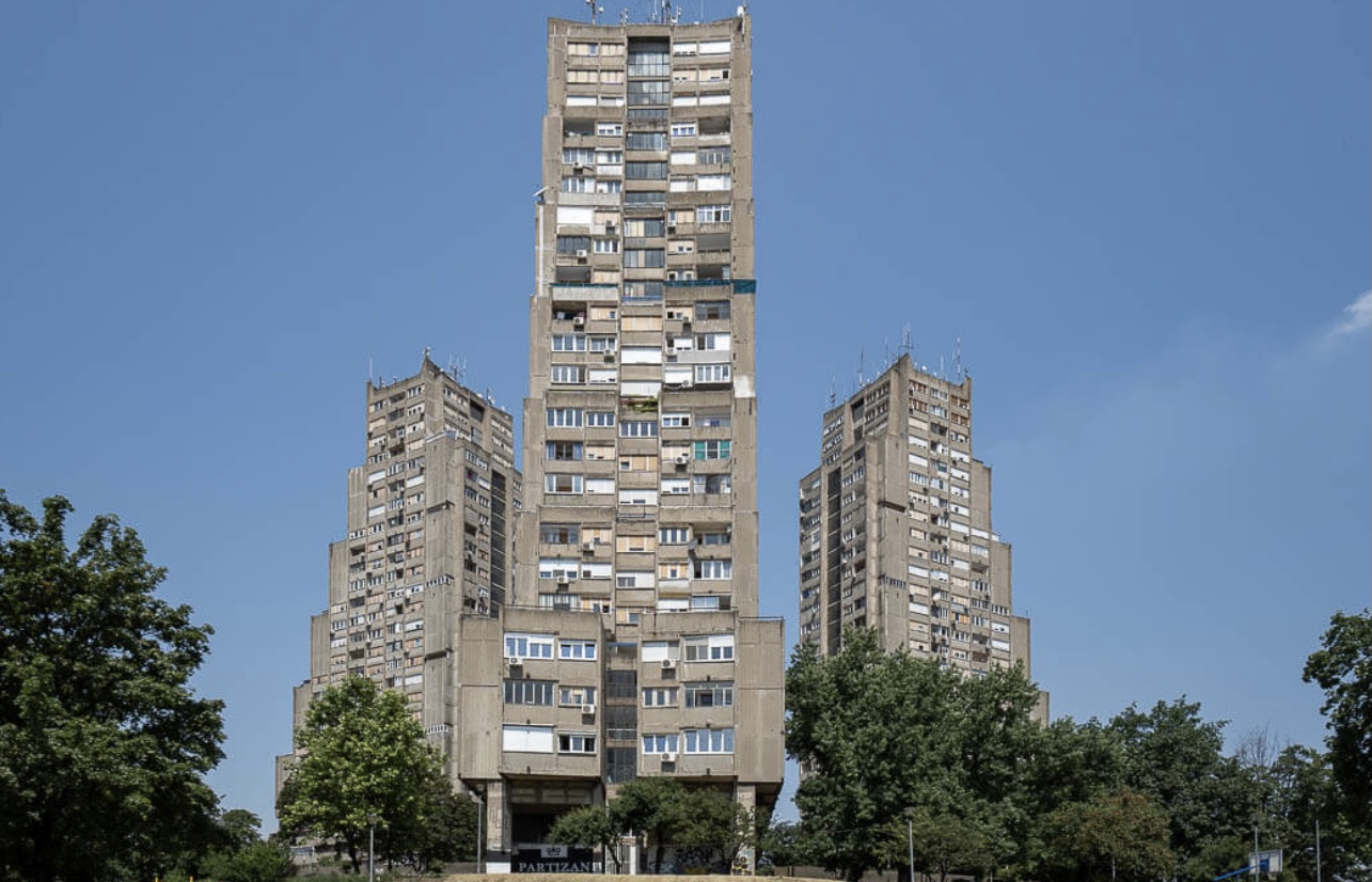
And last but not least, the Karaburma Building, affectionately known as the Toblerone Building. It’s easy to see why.

It was stifling hot in Belgrade. After all that zooming around, there was only one thing to do.


Interesting discussion of brutalist architecture. We came across it In Cambridge. Amid all the elegant college buildings was one in the brutalist style. Quite jarring in that context.
Author
You’re right – when we think of Cambridge, we think of sandstone and spires. But actually quite a few Brutalist buildings were built there between the late 1950s and early 1970s. So many, in fact, that there’s a Modern Cambridge Map which identifies them for a self-guided walking tour if you are interested.